


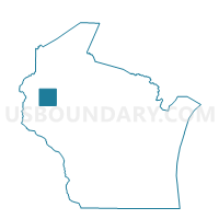
BARRON - T 1 Voting District, Barron County, Wisconsin
About
Outline

Summary
| Unique Area Identifier | 692278 |
| Name | BARRON - T 1 Voting District |
| County | Barron County |
| State | Wisconsin |
| Area (square miles) | 19.41 |
| Land Area (square miles) | 19.41 |
| Water Area (square miles) | 0.00 |
| % of Land Area | 100.00 |
| % of Water Area | 0.00 |
| Latitude of the Internal Point | 45.44271580 |
| Longtitude of the Internal Point | -91.84518730 |
Maps

Graphs
Select a template below for downloading or customizing gragh for BARRON - T 1 Voting District, Barron County, Wisconsin


Neighbors
Neighoring Voting District (by Name) Neighboring Voting District on the Map
- BARRON - T 2 Voting District, Barron County, WI
- CLINTON - T 2 Voting District, Barron County, WI
- CUMBERLAND - T 1 Voting District, Barron County, WI
- RICE LAKE - T 1 Voting District, Barron County, WI
- STANFOLD - T 1 Voting District, Barron County, WI
- STANLEY - T 3 Voting District, Barron County, WI
Top 10 Neighboring County Subdivision (by Population) Neighboring County Subdivision on the Map
- Rice Lake town, Barron County, WI (3,041)
- Stanley town, Barron County, WI (2,546)
- Clinton town, Barron County, WI (879)
- Cumberland town, Barron County, WI (876)
- Barron town, Barron County, WI (873)
- Stanfold town, Barron County, WI (719)